1. Overview of Tay Ninh tourist map
1.1. Location and geography of Tay Ninh province
Tay Ninh is located in the Southeast region, holding a strategic position adjacent to Ho Chi Minh City and bordering Cambodia. It serves as an important trade gateway connecting Vietnam with ASEAN countries via National Highway 22.
Tay Ninh's terrain is diverse, featuring mountains, lakes, primeval forests, and vast green fields. This diversity provides a favorable foundation for developing various types of tourism: nature, spiritual, historical, and border exploration. Ba Den Mountain is the highest peak in the Southern region at 986m, and Dau Tieng Lake is considered one of the largest artificial lakes in Vietnam... These are prominent features on the Tay Ninh tourist map, attracting the interest of many visitors.
Tay Ninh possesses a strategic position on the tourism map of the Dong Nam Bo region. (Source: Collection)
1.2. Role of the Tay Ninh tourism map
The Tay Ninh tourism map 2025 acts as a companion to help tourists orient their journey and conveniently plan their exploration of attractions within the province. As a result, moving, arranging itineraries, and allocating time among the attractions spread across Tay Ninh become easier and more scientific.
Based on the tourism map, tourists can categorize or group destinations by theme. Spiritual tourist spots like Ba Den Mountain, Cao Dai Holy See, and Go Ken Pagoda stand out with their profound religious values. Nature-related spots include Dau Tieng Lake, Nhim Island, and conservation forest areas. Historical relics like the Central Office for Southern Vietnam are for those who love learning about history. Besides, the border area of Moc Bai crossing offers unique experiences of cultural exchange.
2. Notable tourist attractions on the Tay Ninh map
2.1. Sun World Ba Den Mountain
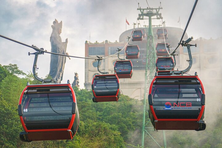
Located in Binh Minh ward, Sun World Ba Den Mountain holds a central position on the Tay Ninh tourism map due to its special scenic and spiritual significance. Ba Den Mountain is likened to the roof of the South, standing at 986m high, and is a large spiritual complex with many ancient pagodas.
The modern cable car system allows tourists to easily reach the mountain peak in a short time. The 72m-high statue of Lady Buddha Tay Bo Da Son on the summit has become a new spiritual highlight, attracting a large number of tourists for worship and sightseeing. Additionally, this area frequently hosts special events and festivals, contributing to the vibrancy of Tay Ninh's tourism landscape.
Notable destinations at Sun World Ba Den Mountain include Van Son cable car station, Ba Den Pagoda, Hang Pagoda, and the summit area where tourists can gaze at the panoramic view of Dau Tieng Lake and the vast plains. Not only does it hold spiritual value, but this place is also a resort paradise amidst the clouds, offering a pure and serene experience for all visitors.
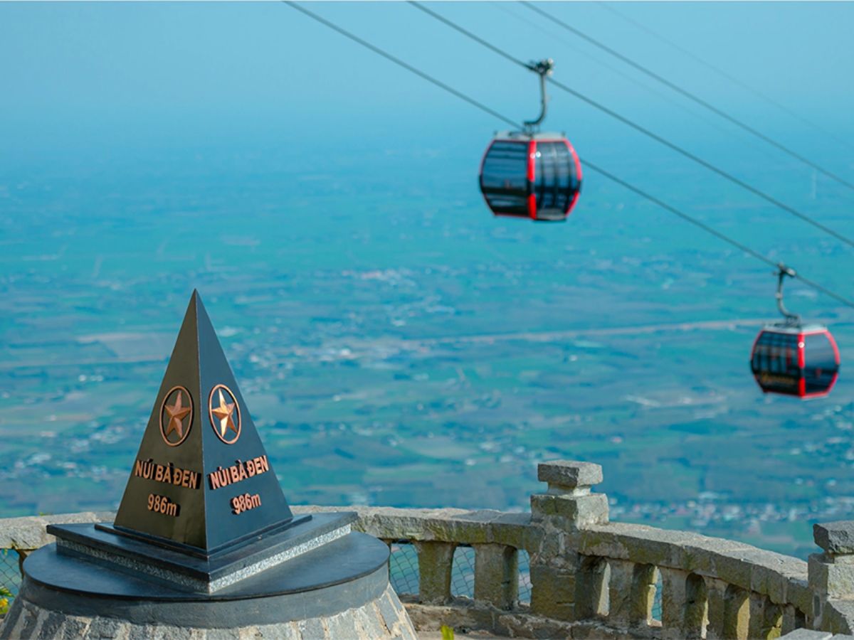
Black Lady Mountain (Nui Ba Den) and the Sun World Ba Den Mountain ecosystem are ideal destinations on the Tay Ninh tourist map. (Source: Collected)
2.2. Dau Tieng Lake and Dao Nhim Island
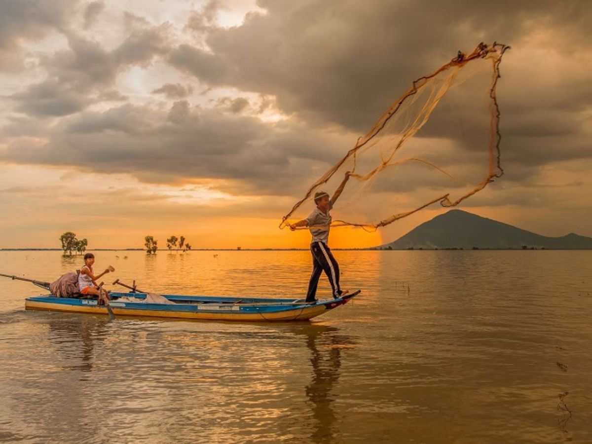
Ho Dau Tieng stretches across Duong Minh Chau and Tan Chau districts, a prominent green gem on the Tay Ninh tourist map . This artificial lake, with a water surface area of over 27,000 hectares, not only supplies water but also captivates with its diverse ecosystem and fresh natural scenery.
Dao Nhim Island is a highlight in the middle of the lake, ideal for camping, kayaking, and organizing family picnics. Moments of immersing yourself in the brilliant golden sunrise over the lake or experiencing an overnight stay on the island will bring a sense of relaxation and peace. Tent rental services are readily available to meet the needs of visitors who wish to connect closely with nature here.
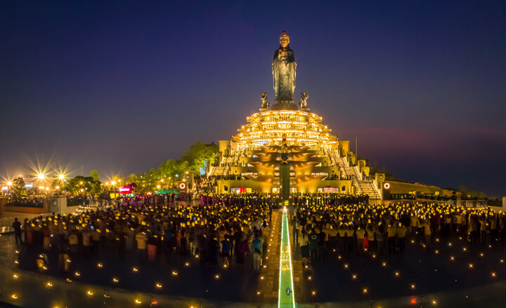
2.3. Cao Dai Holy See
The Toa Thanh Cao Dai, located in Tan Ninh ward, is the most important religious center on the Tay Ninh tourist map . The structure stands out with an architectural style that blends Eastern and Western cultures, creating unique characteristics found nowhere else.
This place frequently welcomes visitors for its solemn ceremonies held at fixed times daily: 6 AM, 12 PM, and 6 PM. The tranquil sound of scriptures, the lingering incense, combined with the sacred atmosphere, create an unforgettable impression.
Visitors to the Toa Thanh not only come to pay respects but also have the opportunity to learn about the philosophy of living towards goodness, harmony, and charity, the core spirit of the Cao Dai religion. Major festivals, such as the Buddha's Birthday Grand Ceremony or the Founding Day, also bring a festive atmosphere, attracting a large number of people and tourists.
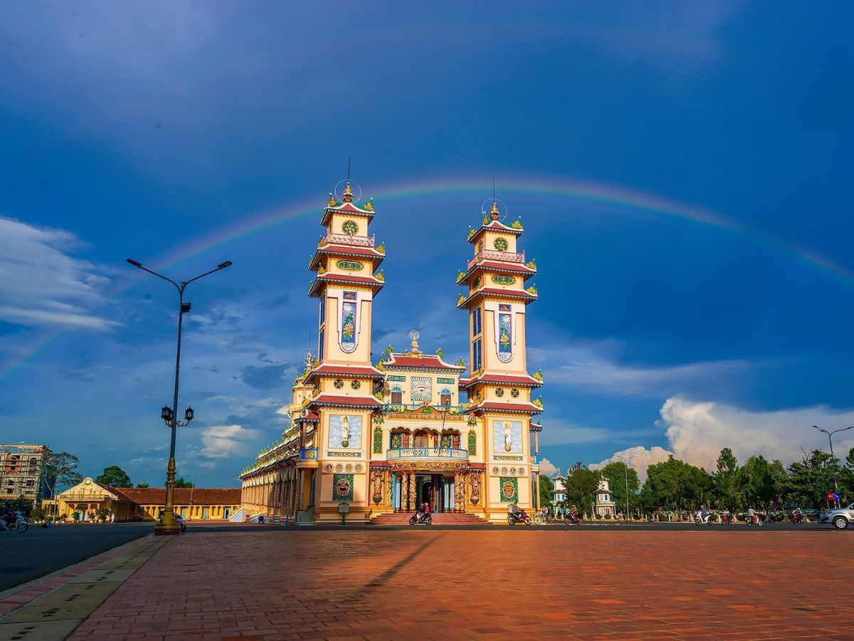
Cao Dai Holy See is an important religious center on the Tay Ninh tourist map. (Source: Collection)
2.4. Go Ken Pagoda and the system of ancient pagodas
Go Ken Pagoda, located in Hoa Thanh ward, is a prominent highlight on the Tay Ninh tourist map for spiritual tourism. Having existed for over a century, this pagoda impresses with its unique architectural blend of Vietnamese tradition and French influence.
The pagoda area is spacious, with large trees providing shade, creating a tranquil atmosphere suitable for pilgrimage and prayer activities. Besides Go Ken Pagoda, ancient pagodas such as Ba Den Pagoda and Hang Pagoda are also highlighted on the map, making it easy for you to plan an itinerary combining visits to multiple religious sites in one trip. Each pagoda carries its own unique imprint, contributing to the rich and distinctive spiritual tapestry of the Tay Ninh region.
2.5. Central Office for South Vietnam Base and Chang Riec Forest
In Tan Lap commune, the Central Office for South Vietnam Base is a historical site clearly marked on the Tay Ninh tourist map . This relic site preserves the original structures such as underground tunnels, residences, and facilities used for wartime activities during the resistance period.
Surrounding the relic site is the Chang Riec forest, which harbors diverse flora and fauna characteristic of a pristine forest region. You can sign up for forest trekking tours to experience the 'returning to the source' atmosphere while listening to heroic historical stories. The combination of historical value and wild nature offers educational significance and an unforgettable experience for visitors.
2.6. Moc Bai Border Gate
Moc Bai Border Gate, located in Ben Cau commune, serves as a key border gateway between Vietnam and Cambodia, clearly identified on the Tay Ninh tourist map . It is one of the largest international border gates in the Southern region, playing a central role in commercial and tourism activities.
Upon arrival, visitors have the opportunity to enjoy the bustling atmosphere of the border area, shop for a variety of duty-free products, or explore eateries serving both Vietnamese and Cambodian cuisines. Moc Bai is also an ideal stopover to buy unique souvenirs before concluding your exploration of Tay Ninh. Experiencing a stroll around the border market, watching people come and go, and feeling the pulse of cultural exchange at the border gate will leave visitors with unforgettable impressions of this vibrant land.
3. Suggested exploration itinerary based on the Tay Ninh tourist map
3.1. 2-day 1-night itinerary to explore Tay Ninh
Starting based on the Tay Ninh tourist map , this 2-day 1-night itinerary is concisely designed to help visitors experience the brightest highlights of this land.
- Day one: Conquering the sacred mountain and immersing in nature
In the morning, visitors depart from Ho Chi Minh City via National Highway 22 towards Tay Ninh, taking about 2.5 – 3 hours of travel. The first stop is Sun World Ba Den Mountain, where you can experience the modern cable car system, venerate the statue of Lady Buddha Tay Bo Da Son, and admire the panoramic view of the Southern plains from the "roof of the Southeast". For lunch, rest and enjoy local cuisine right at the tourist area before continuing the journey.
Around 3 PM, departing from Ba Den Mountain, a 20 km drive leads to Dau Tieng Lake, a large artificial lake in Vietnam. Here, visitors can go camping, kayaking, or simply watch the sunset over the calm lake surface. The fresh atmosphere and picturesque landscape make this an ideal stopover for the night, organizing a BBQ party or campfire by the lake.
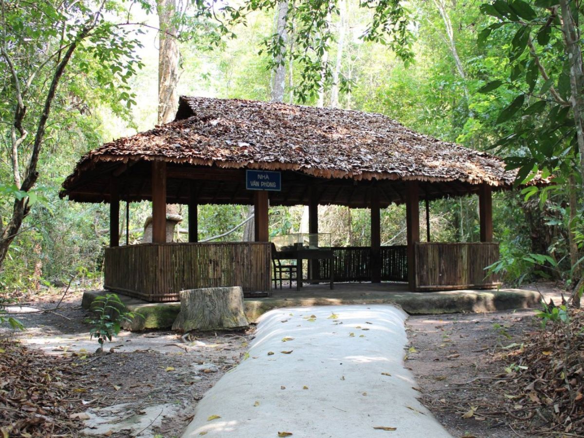
Visit the Central Office for South Vietnam base on the journey to explore Chang Riec forest. (Source: Collected)
- Day 2: Journey back to the source and explore Tay Ninh culture
The next morning, the journey continues with a visit to the Central Office for South Vietnam base and Chang Riec forest, where visitors can hear stories of heroic history amidst the quiet primeval forest scenery. At noon, return to Tay Ninh city center, visit the Cao Dai Holy See, a most unique religious structure in Vietnam, then enjoy local specialties before concluding the trip. This 2-day, 1-night itinerary is designed to be balanced, helping visitors experience nature while learning about the unique culture and history of the Tay Ninh region.
3.2. Experience arranging Tay Ninh travel itinerary
Utilizing the Tay Ninh tourist map helps you easily plan routes by reasonable areas. It is advisable to prioritize grouping nearby attractions such as Sun World Ba Den with Dau Tieng Lake to save time. For attractions located in Tan Lap commune, such as the Central Office base and Chang Riec forest, arrange visits on the same day for itinerary convenience.
If traveling from Ho Chi Minh City, you should start the trip around 6 AM to dedicate the full day to activities. Those who love nature experiences can choose to camp by Dau Tieng Lake to enjoy the fresh air. To make the trip more meaningful and relaxing, it is advisable to choose 3 to 4 suitable attractions per day, avoiding constantly moving to too many places.
4. Guide to using the Tay Ninh tourist map 2025
4.1. How to read the map and tourist zones
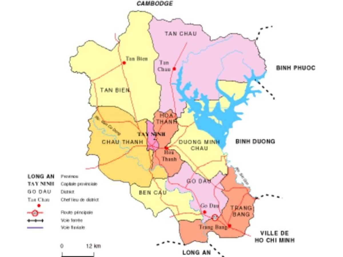
The Tay Ninh tourist map 2025 clearly shows tourist zones to help visitors easily locate prominent attractions. The center of the map is Binh Minh ward, Tan Ninh, where many spiritual sites are concentrated, such as Ba Den Mountain, Cao Dai Holy See, Go Ken Pagoda, along with a system of hotels and restaurants serving accommodation needs.

Use the Tay Ninh tourist map to plan a convenient trip itinerary. (Source: Collected)
The Ba Den Mountain area features Sun World Ba Den Mountain, cable car routes, and hiking trails, indicated by specific symbols. Next to it, the Dau Tieng Lake area appears with campsites, small islands, and ecological zones meticulously annotated. In the border area, Tan Bien commune (Central Office base, Chang Riec forest) and Ben Cau commune (Moc Bai border gate) are all identified by distinct colors and symbols, making it easy for tourists to notice.
4.2. Combining paper maps and Google Maps
Using a combination of Tay Ninh tourist paper maps and Google Maps brings the best efficiency when traveling. Paper maps help you grasp the overall geography, quickly identify clusters of attractions, and spatial relationships within the itinerary.
For detailed navigation, Google Maps supports precise on-the-ground route positioning, estimating travel time, as well as looking up suitable transportation options. The real-time traffic update feature also helps you avoid disrupted routes. You should pre-download area maps to your phone in case of network disconnection in remote areas like Chang Riec forest.
5. Experience visiting according to the Tay Ninh tourist map
5.1. Ideal time to visit Tay Ninh
Based on practical experience, the dry season from December to April is the most suitable period to explore Tay Ninh. During this time, the weather is cool, with almost no rain, making travel and outdoor activities more convenient, especially when planning camping, forest exploration, or mountain climbing according to the Tay Ninh tourist map.
The dry season from December to April next year is a favorable time to travel to Tay Ninh. (Source: Collected)
January and February also coincide with the festival season at Cao Dai Holy See, Sun World Ba Den Mountain, which is very suitable for those who want to experience the traditional festival atmosphere and participate in unique cultural events. However, it is advisable to book accommodation and plan your itinerary early, as this is also a time that attracts many visitors.
5.2. Necessary preparations for a trip to explore Tay Ninh
Thorough preparation will help your trip according to the Tay Ninh travel map become more convenient and comfortable. Regarding attire, prioritize choosing sports shoes suitable for activities, clothes made from cool cotton material, and a light jacket to use in the early morning or evening.
Additionally, bring enough drinking water, insect repellent when visiting forests, a power bank for electronic devices, and a camera to capture beautiful moments. Before the trip, check the opening hours of destinations carefully, paying special attention to the ceremony times at Cao Dai Holy See or the operation of the cable car system at Sun World Ba Den to avoid missing out on experiences.
5.3. When going to border gates, border areas
If planning to travel to Moc Bai border gate or border areas located on the Tay Ninh travel map, you need to prepare sufficient personal documents such as a valid ID card, citizen identity card; if going to Cambodia, a passport is needed, and ensure you are aware of items allowed to be brought across the border.
For a safer trip, it is advisable to travel in groups of 3 to 4 people or more, and limit solo travel at night in border areas. When shopping at duty-free stores, check product quality carefully and keep the receipt. An important factor is to always comply with immigration regulations and avoid carrying prohibited items to ensure a smooth journey.
The Tay Ninh travel map 2025 is a practical source of information accompanying you on the journey to discover the cultural, historical, and natural beauty in this land. The harmony between beliefs, landscapes, traditions, and border experiences will leave indelible marks for every tourist who stops in Tay Ninh.